Archive
Watch this space…
Eric Wilson will update this blog Jan 1st, 2011.
For the latest Storm information
Please watch Local 6
Justweather.com
Tropical Storm Ida approaches Alabama…
Good Morning,
As of 4am this morning, Ida was about 50 miles away from Mobile, AL and closer to the shoreline of the Northern Gulf of Mexico. Ida is expected to slow down and the center should be over Mobile at or around Noon this Tuesday, November 10th, 2009.
Ida’s movement to the east will impact central Florida with wind Tuesday, showers in the afternoon…storms overnight and possibly some severe weather on Wednesday. Once Thursday gets here…much cooler and sunny.
Eric
Ida now a Tropical Storm…
Good Morning,
Ida is now a Tropical Storm..
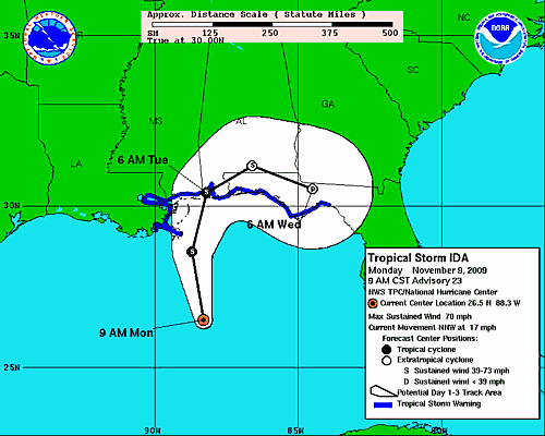
Hurricane Ida, Monday morning update…
Good Morning,
As of this morning, still looking at high confidence for Ida’s landfall very close to Pensacola between 5 and 7 am Tuesday morning as a borderline strong tropical storm-Category 1 hurricane (65-80 mph).
Warnings in effect
From the northern Gulf Coast from Pascagoula, Mississippi eastward to Indian Pass, Florida. A Tropical Storm Warning is in effect from Grand Isle, Louisiana eastward to west of Pascagoula, Mississippi, including New Orleans and Lake Pontchartrain. A Tropical Storm Warning is also in effect from east of Indian Pass, Florida to Aucilla River, Florida.
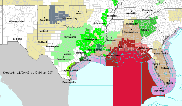
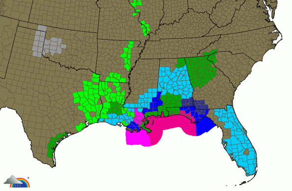
Hurricane Ida:
Here is the 4 am Eastern Time/3 am Central Time Information On Hurricane Ida:
Location: 25.1 North Latitude, 87.9 West Longitude.
Maximum Sustained Winds: 90 mph.
Movement: North-Northwest or 335 Degrees at a forward speed of 16 mph.
Minimum Central Pressure: 988 millibars or 29.18 inches.
Monday’s update
As Hurricane Hunter aircraft finished their rounds this morning it became eveident the shear enviroment we have been discussing is now taking its toll on Ida…which means Ida should continue to weaken from here on out.
As the central pressure continues to rise, and wind speeds continue to decrease the wind shear is expected to increase during the day today. Add cooler water temperatures to this and there isn’t much to suggest Ida will reaach Cat 2 before making landfall Tuesday morning (see above).
The Model outlook as of this morning…
The wind outlook and track
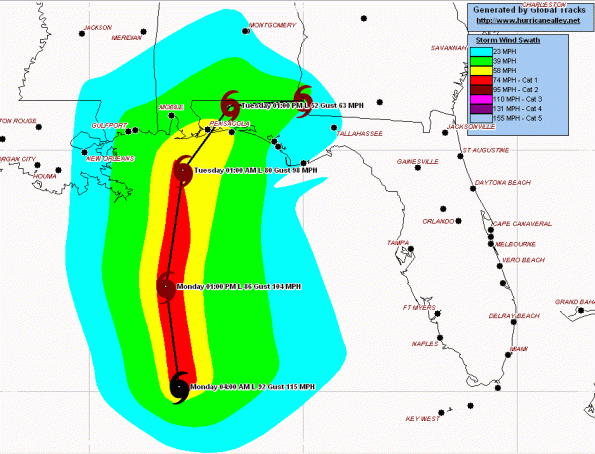
The SHIPS and LGEM take the intensity of Ida down to 75 mph (still Cat 1) by this evening over open water, coming ashore at that same strength.
The GFDL is a little slower, with landfall later on Tuesday (around noon) as a Cat 1 with 75 mph wind near Fort Walton Beach, Florida.
The HWRF moves Ida as a strong Tropical Storm with 70 mph wind but moves it in sooner; with landfall around midnight tonight and splitting the difference between Pensacola and Fort Walton Beach.
The GFS brings Ida closer to Pensacola as well as the multi-model consensus guidance.
The European takes Ida closer to Apalachicola

What about after landfall?…
Ida will expand its coverage and affects in the Southeast starting Tuesday afternoon into the middle of the week. Most of this appears to stay well to the north of us; however, in any forward moving system the most dangerous place to be is in the front right quadrant…which is north of Orlando, but close enough to warrant caution.
Tropical Storm force winds will affect Mississippi, Alabama and Florida along the Panhandle through Wednesday.
As always…
Residents and vacationers along the entire northern Gulf coast from southeastern Louisiana to the Florida Panhandle should continue to monitor local media or your local National Weather Service office for the latest information, including evacuation orders.
A new path comes down at 10am this morning.
Until then, be safe.
Eric
Hurricane Ida evening update…
Good Evening,
Hurricane Ida:
Here is the 4 pm Eastern Time/3 pm Central Time Information On Hurricane Ida:
Location: 22.2 North Latitude, 86.3 West Longitude.
Maximum Sustained Winds: 100 mph.
Movement: North-Northwest or 330 Degrees at a forward speed of 10 mph.
Minimum Central Pressure: 976 millibars or 28.82 inches.
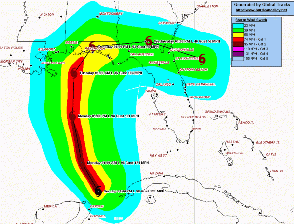
Ok, to begin..Ida should continue to build up speed over the next 24 hours and could very well become a Cat 3 Hurricane Monday afternoon. Beyond that, Ida should weaken before making landfall between Mobile Bay, Alabama and Fort Walton Beach, Florida on Tuesday morning as a Category 1 (80 to 95 mph) hurricane.
Watches and Warnings in effect
First things first, a Hurricane Watch is currently in effect from Grand Isle, Louisiana to Mexico Beach, Florida.
Look for this area to be upgraded to warning status within the next 12 to 18 hours.
What’s been happening during Sunday
Everything is still in line with the morning discussion. Ida continues to reveal central pressure drops (976 millibars at 4pm-970 millibars according to hurricane hunter aircraft. Right now Ida is a Cat 2 hurricane with 100mph wind, and is leaning towards becoming a Cat 3 by this time Monday. The jet stream (northwest of Ida) will act to siphon Ida, giving her a boost intensity wise.
Ida’s forward motion has been consistently around 10 to 12 mph, and should turn directly to the north, keeping her west of Florida.
Model suggestions for landfall location
Checking the European and Canadian models, landfall is suggested west of the ‘official’ track and forecasts southeastern Lousiana.
The HWRF model is on the eastern side of the ‘official’ track and forecasts landfall on the Florida Panhandle.
After Landfall…
This is the wrinkle I just can’t iron out this evening, and I’m not alone. After Ida makes landfall, there is an abrupt turn to the east. So, for accuracy sake I will mention everyone in the Southeast and the Mid Atlantic coast should closely watch where Ida goes Tuesday night/Wednesday morning. Here’s why…what’s left of Ida could combine with energy moving offshore and produce a huge ocean storm later in the week. Let’s jump off that bridge when we get to it.
Residents and vacationers along the entire northern Gulf coast should closely monitor local media or local National Weather Service office for the latest watches and warnings.
Here are some great sites to keep you informed…
Live News Cameras Hurricane Center
Broadcast Coverage From Internet Partnership Radio
Broadcast Coverage From Hurricane City
Broadcast Coverage From The Weather Radio Broadcast Network
WWL-TV New Orleans, LA
WWL Radio AM870/FM105.3 New Orleans, LA
WDSU Channel 6 New Orleans, LA
WGNO ABC26 New Orleans, LA
WVUE Fox8 New Orleans, LA
NOLA.com New Orleans, LA
WLOX-TV 13 Biloxi, MS
ABC 33/40 Birmingham, Alabama
ABC 33/40 Weather Blog
WKRG News 5 Mobile, AL
NBC15 Mobile, AL
Fox10 TV Mobile, AL
WJHG 7, Panama City, FL
WMBB News 13, Panama City, FL
Here are some webcam links as well for the area of concern…
Webcamplaza.net
Southeast Louisiana Webcams (HurricaneCity)
Louisiana Webcams
Louisiana Webcams (WeatherMatrix)
Louisiana Webcams (ABC Webcam)
Mississippi Webcams
Mississippi Webcams (WeatherMatrix)
Mississippi Webcams (ABC Webcam)
Alabama Webcams
Alabama Webcams (WeatherMatrix)
Alabama Webcams (ABC Webcam)
Florida Panhandle Beach Cams
Florida Gulf Coast Cams
Bourbon Street, New Orleans Webcam
New Orleans, Louisiana Webcam #1
New Orleans, Louisiana Webcam #2
New Orleans, Louisiana Webcam #3
New Orleans, Louisiana Traffic Cams
Biloxi, Mississippi Webcam
Gulf Shores, Alabama Webcam #1
Gulf Shores, Alabama Webcam From ABC 33/40
target=”new”>Mobile, Alabama Webcam
Hurricane Ida, now the path agrees…
Good Afternoon,
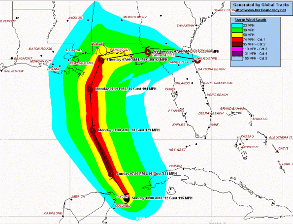
Now the path of Ida is now more in line with the previous post this morning
Ida, as near a Hurricane Cat 1, reaching the gulf tonight and racing due north towards Mobile, Alabama and Pensicola, Florida Late Monday night into Tuesday Morning.
Confidence is low regarding Ida’s impact on Central Florida at this time.
The clouds you see this afternoon will be connected to Ida’s outflow boundary, and the steamy nature to the air as well.
Here is the latest wind forecast and path of Ida
Hurricane Ida…Florida’s Problem Tuesday?
Good Morning,
Hurricane Ida:
Here is the 6 am Eastern Time/5 am Central Time Information On Hurricane Ida:
Location: 20.8 North Latitude, 85.7 West Longitude.
Maximum Sustained Winds: 90 mph.
Movement: Northwest or 325 Degrees at a forward speed of 12 mph.
Minimum Central Pressure: 983 millibars or 29.03 inches.
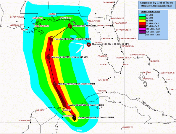
The above is the current wind speed forecast…which is a little slower than most are thinking when it comes to timing landfall and location seems a bit west (see below for adjusted landfall and timing).
As it stands, Ida will continue to build once it crosses into the Gulf of Mexico, possibly reaching Cat 2 either today or later tonight. As the water is very warm and the environment is favorable, Ida could pack 105 mph winds internally later this afternoon.
Monday
Ida will track into somewhat cooler seas and start running into some shear, however it will take longer to see Ida die down as the southwest wind shear will cancel the shear to the north for about 24 hours.
The Models
The GFDL model has Ida to make landfall late Monday night near Mobile Alabama as a Cat 1
The HWRF forecasts Ida to come ashore Pensacola, Florida around midnigt Monday night as a Cat 1.
The GFS forecast Ida making landfall in the extreme western Florida panhandle on Tuesday morning.
The European model forecasts Ida will be ashort Monday night, along with the aforementioned models to include the Canadian
Movement
As Ida moves to the northwest at 12mph, Ida will come very close to the Yucatan Peninsula this afternoon, then track right into the heart of the Gulf and pick up forward motion speed Monday.
So, for now…here are the adjustments
Ida should be in the northern Gulf of Mexico by Monday evening and then come ashore somewhere between the Apalachee Bay, Florida and Gulfport, Mississippi with the most likely area between Mobile, Alabama and Fort Walton Beach, Florida.
Landfall with wind between 65 mph (Tropical Storm) and 80 mph (Cat 1), sometime late Monday night or early Tuesday Morning.
Until then…
Ida will be a soaker, regardless, with high seas and heavy rainfall starting Monday and lasting Tuesday. Interests in the Northern Gulf Coast need to stay aware of changing conditions, and keep up to date with Tropical Storm/Hurricane Watches which are issued by local NWS offices over the next 48 hours. If Ida cruises into the Gulf and picks up speed, which is what this blog is suggesting, then NWS offices will quickly pick up on that and watches will be issued accordingly.
I will have more tonight
Eric
New Model Runs…work in progress..

Ida, now a Tropical Depression…for now
Good Morning,
Here is the short of it: Once Ida reaches the Gulf of Mexico, she could move northeast on Tuesday as a Tropical Storm and possibly a Hurricane (Cat 1). As it stands, Ida could come ashore just north of Tampa and the eastern part of the Florida Panhandle either Thursday or next Friday as a strong Tropical Storm or Cat 1 Hurricane.
Here are Idas numbers as of this morning:
Tropical Depression Ida:
Here is the 4 am Eastern Time Information On Tropical Depression Ida:
Location: 14.4 North Latitude, 84.1 West Longitude.
Maximum Sustained Winds: 35 mph.
Movement: North or 350 Degrees at a forward speed of 6 mph.
Minimum Central Pressure: 1005 millibars or 29.68 inches.
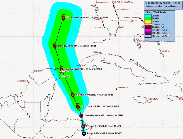
And the latest plot
Here’s what’s going on…
Ida sits along the border of Honduras and Nicaragua as the sun rises this friday morning, Ida is mearly a tropical depression…for now. I have checked areas most likely for deeper convection and it lies just outside to the east and north of center…in the water.
It looks like Ida, according to satellite loops I have watched this morning, will move back into the water as soon as tonight as late as Saturday morning. Once over the water, Ida is expected to strengthen again…now, the question becomes “To What?”. Here is a look at what I’m working with…
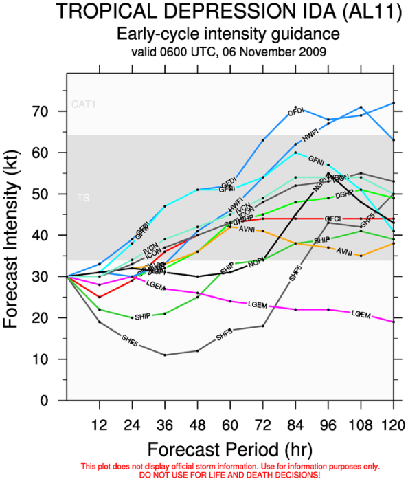
With sea surfaces quite warm in this forecasted area and with a favorable environment for enhancement it seems quite possible Ida will at least reach Tropical Storm status over this weekend. Right now, looking at the wind shear, Ida could intensify into a weak Category One Hurricane by Monday morning as it enters the Gulf of Mexico
As Ida moves north (at 6mph) and should stay moving in this direction over the weekend, with little or no movement to the west or east. Once Ida moves into the Gulf of Mexico…things become tricky, and here’s why. It appears a trough of low pressure is timing it’s arrival at the same time in the Gulf, which (if this comes true) will push Ida to the Northeast towards Florida’s Gulf Coast…as a Tropical Storm, possibly a Hurricane.
What the models are saying…
Right now, the cluster of model guidance seems to all follow this assumption..turning the center of the system towards our coastline Wednesday…right now between Tampa and the Florida Panhandle.
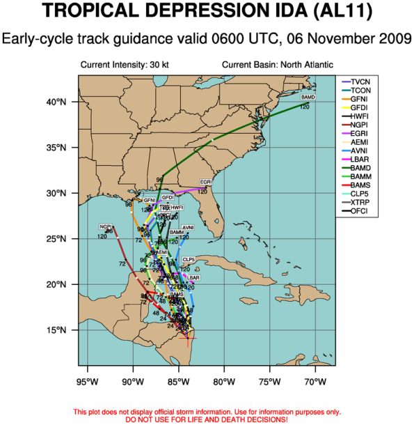
There is another possibility, which has the trough of low pressure missing Ida alltogether…which would leave Ida meandering in the Gulf early next week…and not threaten our coastline. 🙂 In fact, if this happens the shear environment would eat Ida up and render her powerless. Lets hope.
So…
Once Ida reaches the Gulf of Mexico, she could move northeast on Tuesday as a Tropical Storm and possibly a Hurricane (Cat 1). As it stands, Ida could come ashore just north of Tampa and the eastern part of the Florida Panhandle either Thursday or next Friday as a strong Tropical Storm or Cat 1 Hurricane.
I will keep you posted every day this weekend. Until then, a little breezy today and cooler than normal this weekend.
Eric
Hurricane Ida as of 7am this morning…
Good morning,
As of 7am this morning, Ida is now a Cat 1 Hurricane.
Hurricane Ida:
Here is the 7 am Eastern Time Information On Hurricane Ida:
Location: 12.8 North Latitude, 83.4 West Longitude.
Maximum Sustained Winds: 75 mph.
Movement: Northwest or 310 Degrees at a forward speed of 7 mph.
Minimum Central Pressure: 987 millibars or 29.15 inches.
See post from this morning regarding tracks…I will post the 8am track runs as they come in on this thread.
Eric


