Archive
Watch this space…
Eric Wilson will update this blog Jan 1st, 2011.
For the latest Storm information
Please watch Local 6
Justweather.com
Back To Normal….by Friday
Good Morning,
OK…I get it. Floridians don’t like the cold. Here’s what we expected overnight into Monday morning…more cold weather.
Take comfort in knowing it will warm up here before anywhere else by Friday. Normal for this time of year is 72, and we will be above normal by Friday…and it will stay above normal through the weekend.
The Midwest will see the warm up first…then, as we get closer to ending the week…we see temps return to 70s
Non weather related info…if you have interests in California, here is what happened
A magnitude 6.5 earthquake struck off the shore of Northern California at about 4:27 p.m., PST, on Saturday. According to the U.S. Geological Survey, the earthquake epicenter was about 33 miles offshore of Eureka, California, at a focal depth of 13.5 miles. The undersea tremor did not prompt a tsunami warning. Aftershocks followed the initial offshore earthquake, with the strongest reported at 4.5-magnitude. Aftershocks were forecast to for days to come. Power outages hit the region as lines snapped leaving about 25,000 blacked out temporarily, according to Pacific Gas and Electric Co. outages occurred in Humbolt County, the county in which Eureka is located. There were no immediate reports of injuries or serious damage.
Flurries in Northern Florida?….
Will there be snow in Florida? Depends on who you ask. Ask any forecaster responsible for Central Florida, and the answer is no. However, ask a forecaster responsible for Northern Florida, and the answer is…maybe.
The only graphic that could locally support the idea above was posted this morning from the Jacksonville National Weather Service Office below.
They explain moisture will be present when a big enough wedge of freezing air along with a left over upper level disturbance combines early Saturday Morning; which should produce flurries north of Flagler Beach and south of Saint Augustine.
This forecast could change a lot in the next 48 hours, and I will be watching it very closely.
Eric
Chilly start to the week…
Good Morning,
While advisories and even a warning for freezing temperatures were posted last night, I didn’t find any temperatures below freezing this morning. Now, Tuesday will still be chilly at the bus stop; however, it won’t be any where near freezing. I expect temps to range from mid to upper 40s by sunrise (7:13am).
Looking ahead, temps will bounce back above normal (73) by Wednesday, and could reach near 80 by Friday. There is a wrinkle with those 80s towards the end of the week, I expect another exchange of cooler weather by this weekend….which means we could have thunderstorms finish the week again.
Strong Storms from 11am to 3pm…
Good Morning,
After some doppler indicated tornado warnings this morning
The first was issued at 4:23
and another, one hour later at 5:33am
both early this morning in Brevard county; no damage has been reported so far. Again, it was dark and we are left with the best information sans any visible confirmation. Best to err on the side of safety before the sun rises as most of us are asleep.
Now, on to the rest of the day.
Large area of rain approaching east Florida…numerous strong showers over the Atlantic
Through 900 AM…a storm system over the Gulf of Mexico will push into the west Florida panhandle…dragging a squall line toward the western peninsula.
A large area of light to moderate rain ahead of the squall line will overspread the central peninsula by mid morning. In addition…strong showers with very heavy rain and will push north over the open Atlantic waters. These showers may generate waterspouts…but are expected to remain offshore. Heavy rain over the coastal counties overnight has saturated the ground in many areas…especially over south Brevard and central St. Lucie counties. Any additional heavy rainfall may cause localized flooding problems in low lying and poor drainage areas.
As of 7:44am this morning a Tornado Watch was posted for areas south of Orlando and Melbourne; and is effect until 1pm this afternoon.
Now, this area (below) also has to be concerned with severe storms. Notice, Orlando is not included (good news). But Melbourne’s coast can’t be ruled out just yet.
Also, I am not picking up much in the way of electricity heading our way…which is an indicator of instabilitiy (Tornadic precursor)…and right now the forecast for severe weather today in Orlando is leaning towards heavy rain and gusty wind, with any rotating storms well south of Brevard County.
So, with the above discussion and diagram I am glad to share the threat of severe weather for Orlando this Friday has decreased since sunrise this morning.
Of course, we will continue to track any rouge storms during the day.
Get ready for colder mornings
Soggy Veterans Day…then cooler days await.
Good Morning,
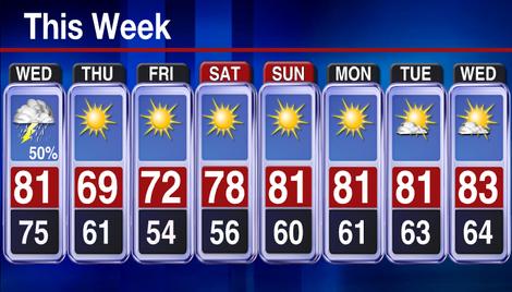
Ida continues to spin in Georgia, and as of this morning the frontal boundary of cooler air sits off to our west in the Gulf. This means one last day with high humidity, thunderstorms and wind gusts. After tonight, which is when I expect the cooler air to settle in, you will notice a change in the air.
Thursday morning temps won’t be the coolest either, check out the morning low on Friday…low 50s! When the air is drier, as it will be this weekend, it is easier to warm up…so we will be back in the low 80s this weekend; yet the humidity will be very low. Just about perfect!
Enjoy!
Eric
Don’t worry, cooler days are just around the corner…
Good Morning,
Strong storms in the midwest won’t be coming into Florida, and the strong drop in temperatures seen in the Mississippi Valley today won’t be coming either; however, slightly cooler temperatures with out the humidity will be here by monday.
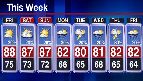
Don’t forget to fall back this weekend! Best to remind yourself as your counting the candy Saturday Night…in fact, here are the conditions for Trick or Treating in Central Florida.
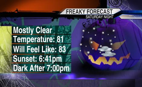
You might need the bug spray too.
Warmer Days Ahead…Snow in Denver
Good Morning,
As Rick approached land overnight, he is soaking Central Mexico right now. Rick is an important feature to our weather here in the U.S., as he is pushing tons of moisture north into Texas and Colorado today…and later into the mid-Mississippi Valley by Friday.
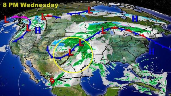
So…a stormy day from Northern Texas/Eastern Colorado to Nebraska will mean travel delays are likely at the airport this afternoon. I also see snow forecasted for Denver, or at least in the area today..
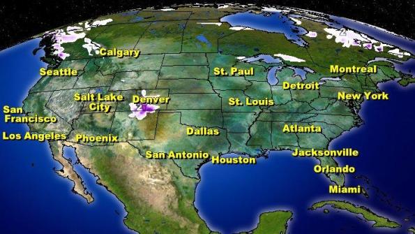
So far, as the High moves out east our weekend looks the same.
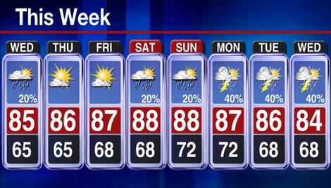
Enjoy!
Eric
Chilly, Windy Days Move Out…
Good Morning,
It looks like the colder starts to our mornings are soon to be just a memory. Here is what’s taking place
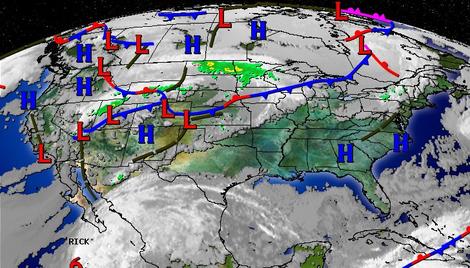
High Pressure is just to the north of us (in Georgia Tuesday morning) and has been tapping into the colder air from the north. As this High moves out to the Atlantic by Thursday, our air will be coming from the south and temperatures will reflect it. I expect afternoons to be a tad warmer than what we should see this time of year, as the average high for this time of year is 84
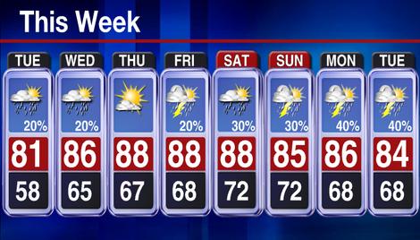
Have a great week!
Eric
Cooler weather on the way…
Good Morning,
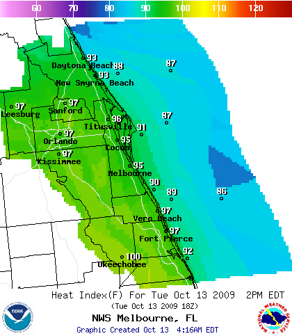
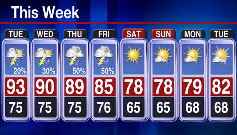
Today, another hot one. Heat Index values (see below) are still up in the upper 90s. Yet, still looking for some cooler weather this weekend. One issue, would be thunderstorms Thursday and Friday as the cooler air carves its way into our backyards.
Here is the timing as it stands on a Tuesday…as this area of low pressure (storms) combines with a push of cooler air from the north over Georgia on Wednesday night.
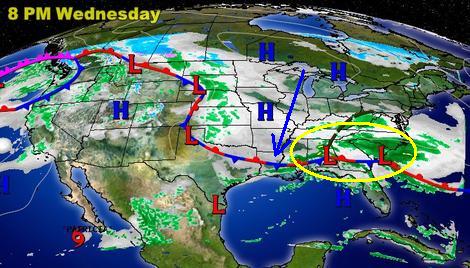
I expect the system to cross to our north overall…yet the trailing cold front should kick off thunderstorms Thursday and Friday until it finally clears out into the Atlantic and changes the air quality dramatically for Central Florida.
Have a great day!
Eric


